AheadX Launches Drone Image Free-control Surveying Solution
In the application of high-precision surveying and mapping, operators often need to traverse the mountains to arrange image control points, which consumes a lot of time and energy.
In the field of high-precision drone surveying and mapping, AheadX has launched a image free-control surveying and mapping solution, which greatly improves the efficiency of users' aerial survey operations

Introduction
The core of this image-free control surveying and mapping solution is to strictly control the quality of each link such as positioning, shooting, solving, etc., to improve measurement accuracy and reduce errors, and finally achieve the multi-rotor 1:200, fixed-wing/hybrid Wing UAV 1:300 high mapping resolution, under the premise that no ground image control points are arranged, the surveying and mapping results reach usable accuracy.
--Key Technology--
AxTimeSync-Time synchronization technology
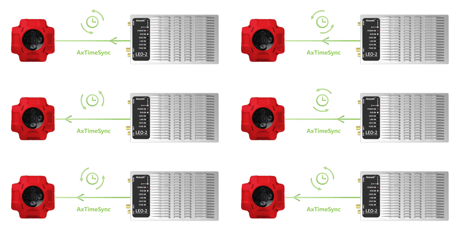
Through the AxTimeSync technology independently developed by AheadX, the LEO 2 GNC and camera system time can be synchronized in microseconds, which greatly improves the accuracy of POS data.

Time synchronization connection diagram
Camera installation correction algorithm
The LEO 2 GNC can correct the position and attitude deviation between the camera and the LEO-2 through the algorithm, and eliminate the measurement deviation caused by the installation.

Schematic diagram of camera installation position correction
In the multi-rotor drone surveying and mapping scene, the camera installation will generally increase a certain forward tilt angle to compensate for the drone attitude changes during the flight, thereby improving the quality of the original film. LEO 2 can adjust various camera installation angles to meet various installation requirements.
High precision RTK
This solution can realize RTK through network RTK (Qianxun FindCM, etc.) or high-precision ground differential reference station (Hi-Target UBase, etc.) to ensure that drones can achieve high-precision RTK operations in a variety of complex environments.
--Specifications--
LEO2-GLC GNC System
The LEO2 GLC version is a guidance navigation and control system newly released by AheadX for the application of high-precision surveying and mapping.
| RTK level measurement accuracy | 1cm+1ppm |
| Vertical measurement accuracy | 2cm+1ppm |
| Time accuracy | 20ns RMS |
| Attitude measurement accuracy | <0.1° |
| Heading measurement accuracy | <0.08° |
| Speed measurement accuracy | <0.03m/s |
| Operating temperature | -40-75℃ |
Share Series Camera

| Share102S | Share202S | Share 6100 | |
|---|---|---|---|
| Effective Pixels | 24.3MP,total pixels≥120MP | 42.4MP,total pixels≥210MP | 61MP |
| Sensor Size | APS-C(23.5*15.6mm) | Full Frame(35.9*24mm) | Full Frame(35.7*23.8mm) |
| Resolution | 6000*4000 | 7952*5304 | 9504*6336 |
| Focal Length | 35mm | 40mmX1/56mmX4 | 40/56mm |
UBase Ground Differential Reference Station
Taking into account the operation without network, in addition to supporting CORS network RTK, it is also compatible with UBase base station
| RTK level measurement accuracy | 1cm+1ppm |
|---|---|
| RTK vertical measurement accuracy | 2cm+1ppm |
| Time accuracy | 20ns RMS |
| Operating temperature | -40-65℃ |
Free image control actual operation
The image-free control operation does not require the deployment of image control points, and at the same time requires very little equipment, only one person and one vehicle can quickly start field operations.

--Surveying and mapping route planning--
The SPACE V3D ground station software can automatically generate area, band, and surround scanning routes with one button, and can import high-precision three-dimensional map models. This will greatly improve the map elevation accuracy and be suitable for a variety of refined operation scenarios.
--Camera check--
SPACE V3D is adapted to Share Series cameras. The camera can be quickly configured and working status checked through the ground control software to improve field efficiency.

--Flying--
SPACE V3D brings a more intuitive display of flight effects, and controls the current drone operation status more intuitively through a 3D perspective.
Multirotor area surveying
Quadplane big area terrain follow flight and mapping
--Data Output--
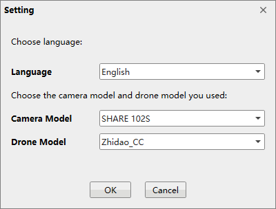
Open Share Aeronautical Survey Manager, when selecting the drone model, the user of the CC calculation software selects Zhidao_CC, and the user of DJI Maps selects Zhidao_DJI, as shown below.

Select the order, copy the corresponding order
Find the corresponding copy folder path, the xlsx format file is the POS data required by CC users.
Select the order, copy the corresponding order
Users of DJI Terra can directly import the photos in the folder. The folders in the following figure correspond to the photos of the rear, front, lower, right and left lenses in turn.
At the same time, LEO 2 can save more than 200 hours of flight log, POS data and PPK data. If users use other cameras for operations, they can quickly export flight and operation data through the USB Type-C interface.
Airborne POS data is compatible with CC and DJI Terra post-processing software
Data Process
Import the POS data into the CC post-processing software and submit the air triangulation calculations. The calculation results are shown below. There is no layering and the air triangulation calculations pass.

Multi-rotor block surveying and mapping CC aerial triangulation results

Results of Triangulation Controlled by Dajiang Zhitu for Large Area Strip Surveying of Hybrid Wing
--Accuracy analysis--
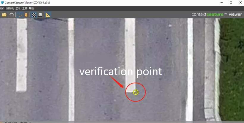
After importing the ground verification point, perform a preliminary inspection, as shown in the figure below. The coordinates of the verification point and the photo verification point are basically completely overlapped, indicating that the data is qualified.


Initial inspection of verification points
Use ContextCapture Viewer software to view the generated 3D model, compare the position of the verification point with the coordinates of the corresponding position in the 3D model to verify the accuracy of the results.


Check verification points in the 3D model
| North position | East position | Height | |
|---|---|---|---|
| Control point | 3658389.091 | 505379.8794 | 50.4587 |
| Model selection point | 3658389.07 | 505379.87 | 50.47 |
| error | 2cm | 1cm | 2cm |
Error analysis (1:200 mapping resolution)
It can be seen from the data in the above table that the final error of the results of the image-free control operation is within 2cm, which meets the accuracy requirements of the image-free control.
--Model results display--
Note: All the above data are obtained from real image-free control operations under different landforms.